
Walking Trails

Loriga Gorge
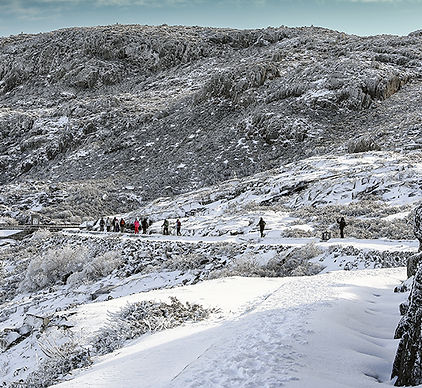
The Loriga Gorge Route (PR5 SEI) is a route that connects the upper plateau of Serra da Estrela to the town of Loriga, in Portugal. This route offers a landscape marked by glacial remains, characteristic of the last cold period that affected the region. During the walk, four depressions known as covões stand out: Boieiro, do Meio, da Nave and Areia. These areas are home to rare species of fauna and flora typical of mountain environments. Although the route is less than 9 km and is predominantly descending, the high altitude and the characteristics of the terrain require extra attention.
It is recommended to avoid the trail during the coldest months of the year1.
-
Linear Distance: 8.8 km
-
Average Duration: 4 hours and 30 minutes
-
Minimum Altitude: 768 meters
-
Maximum Altitude: 1838 meters
-
Difficulty: Hard
Beginning and end:
-
Home: Salgadeiras (EN338/KM27)
-
End: Largo da Carreira, Loriga

Rossim Valley
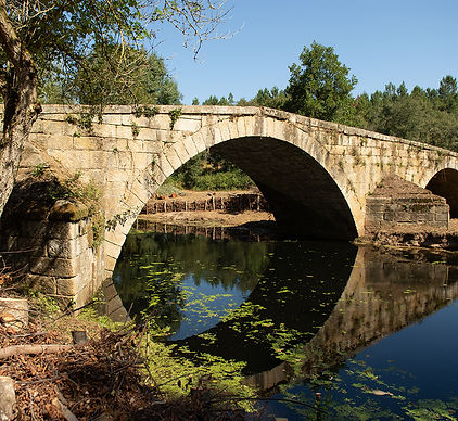
Route PR11 (SEI), also known as the Rossim Valley Route, is a short hiking trail that runs along the Fervença river valley, connecting the Rossim Valley and Sabugueiro, in Seia, Portugal. This route follows ancient transhumance trails, crossing a vast area dominated by broom and sargassum scrub, large granite outcrops, and verdant high-altitude meadows. Highlights include the Perdiz Valley, a vast meadow covered in a wide variety of mountain plants in spring, and the Covão do Costa, where large granite boulders intersperse with Caldoneira scrub. Near Sabugueiro, the Fervença waterfall and the picturesque Porto Cabrito bridge are worth mentioning.
Here are the summary details of Route PR11 - Vale do Rossim:
Distance: 6.34 km
Approximate duration: 3 hours
Average Duration: 3 hours and 30 minutes
Difficulty: Hard
Fervença Route
The Fervença Route begins in the village of Sabugueiro, where traditions and customs associated with pastoral activity remain part of daily life.
The route crosses a typical mountain landscape surrounding the village and a rugged area crossed by the Covão do Urso and Fervença streams.
The landscape is dominated by pine forests, marshes, heather thickets, and broom. In the Covão do Urso, a depression shaped by glacial action, one can see the numerous sedimentary deposits, whose materials were transported by the ice of the last glacial period. Near the Carnazeda headland, high on the slope, the waters of the Fervença stream cascade down. From this vantage point, one enjoys a sweeping view of the valley and the village. Downstream, this stream meets the Cabaço stream.
Part of the route coincides with the Rota do Vale do Rossim and GR22 AHP.
Distance: 4.6 km
Approximate duration: 2h30 hours
Average Duration: 3 hours
Difficulty: Easy

Caniça Route
The Caniça Route crosses a rugged valley, where water is a constant presence and the landscape, in addition to its rural character, is composed of chestnut groves, pine forests, marshes, scrubland, and rocky outcrops. A highlight is the Souto da Lapa, a grove of centuries-old chestnut trees that supports a high diversity of fauna and flora species, some of which are rare in Portugal.
In the river and its surroundings, the references are the Caniça Falls, the Devil's Horns, a curious rock formation, and the Sumo Hole, an area where the watercourse runs underground.
Although not very long, the nearly 500 meters of positive and negative elevation gain make this route challenging. Part of the route coincides with one of the stages of the GR22 AHP.
Here are the summary details of Route PR11 - Vale do Rossim:
Distance: 6.96 km
Approximate duration: 3 hours
Average Duration: 3 hours and 30 minutes
Difficulty: Hard
Seia River Route
The Seia River Route is a hiking trail that covers part of the Seia River valley. The route begins in the center of Seia and connects the villages of Santiago, Folgosa do Salvador, Santa Comba, Sameice, Pereiro, and Vila Verde.
Leaving Seia, the route runs through an area crossed by the Maceira River, heading towards Folgosa do Salvador. Here, on a Philippine bridge, the route crosses the river, heading towards Sameice, while a diversion leads to the Seia Mountain Biking Center and the village of Santa Comba.
From Sameice, the trail descends to the Pereiro bridge, where a new branch provides access to the northern slope of the valley and Pereiro. Downstream from the bridge, the river flows through a canyon, framed by granite outcrops, forming one of the route's most iconic landscapes. From here, the trail continues to the Pífaro dam and Vila Verde, where it ends.
Distance: 15.6 km
Approximate duration: 5h40 hours
Average Duration: 6 hours and 30 minutes
Difficulty: Hard
Tapado Route
The Tapado Route, so named because it refers to fields enclosed by loose stone walls, begins in front of the Travancinha village Parish Council building, where the information panel is located. This short route is not marked conventionally (single yellow line), but maintains the same purpose of orientation as the official short route markings. This signage is the responsibility of the entities promoting this route (Parish Council, CISE, and some local companies linked to tourism and well-being). It is an easy route, with little elevation gain and runs essentially along well-defined paths, ideal for families, interesting in terms of scenery, allowing us to admire the mountain ranges that can be seen on the horizon (Estrela, Açor, Caramulo, Montemuro). It is well marked on this date, but you should not neglect the help of GPS or the route map. Distance: 7.4 km Approximate duration: 4 hours Average duration: 4 hours and 30 minutes Difficulty: Easy
Seia River Route
The Seia River Route is a hiking trail that covers part of the Seia River valley. The route begins in the center of Seia and connects the villages of Santiago, Folgosa do Salvador, Santa Comba, Sameice, Pereiro, and Vila Verde.
Leaving Seia, the route runs through an area crossed by the Maceira River, heading towards Folgosa do Salvador. Here, on a Philippine bridge, the route crosses the river, heading towards Sameice, while a diversion leads to the Seia Mountain Biking Center and the village of Santa Comba.
From Sameice, the trail descends to the Pereiro bridge, where a new branch provides access to the northern slope of the valley and Pereiro. Downstream from the bridge, the river flows through a canyon, framed by granite outcrops, forming one of the route's most iconic landscapes. From here, the trail continues to the Pífaro dam and Vila Verde, where it ends.
Distance: 15.6 km
Approximate duration: 5h40 hours
Average Duration: 6 hours and 30 minutes
Difficulty: Hard